Friday, June 9, 2017

Hike of a couple of weeks ago... Vanson Peak and Cathedral Falls


Over Memorial Day Weekend we camped at Taidnapam Park ... about which more later. Ms. "Can't Sleep Past Dawn in a Tent" (ahem) was awake at 5:30, so we got up, had breakfast, and headed out.

We pulled out of the campground at 7am and during the 5-mile drive up the one-lane road to the trailhead I just kept thinking how great Woody is doing. Who's a good boy? Woody. There was a lone truck at the trailhead as we set out.

The trail was green and narrow at the beginning.


Here's a TMI moment for you. Feel free to scroll down to the lovely view below.

Driving up to the trailhead I started to feel a little odd. Just odd. Within a few yards of the trailhead, it was clear I needed a pit stop. In a place with no privy. It was clear I would need to ... join the society of bears.

Luckily I had been to a talk at the Mountaineers -- "Hiking and Backpacking Tips for Woman" -- where this matter was discussed in great detail. I marched off the trail, dug a "cat hole" and well... you know. I covered it up and emerged from the woods triumphantly. Let's just put this down to Kilimanjaro training.

We caught this lovely view and headed on down the trail.


The trail was empty and glorious -- winding up and down through the woods.


We crossed a few small creeks, admired a tiny waterfall, and had the world to ourselves.


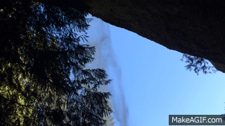
At 1.1 miles we reached the natural highlight of the hike: Cathedral Falls. I knew there was a big waterfall, where the trail went behind the falls, but I didn't quite know what to expect. Kapow.


Whenever I see a waterfall I just wonder where the water is coming from. So. Much. Water.


Seriously, where is all this water coming from?

Cathedral Falls

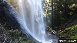
I hadn't known what to expect with the trail going behind the falls. Would it be narrow and slippery? Would we want to go under it? Guess I needn't have worried:

Wil on the trail behind Cathedral Falls
Sunny on the trail behind Cathedral Falls
Yep... plenty of room. And, of course ... THE BACK SIDE OF WATER! (And we didn't even need to go to Disneyland to see it!)

Cathedral Falls - the back side of water

After oohing and aahing at the falls for a while, we continued on. We caught glimpses of the river:


And even managed not to miss the turn off toward Vanson Peak.


For the most part, the trail was in decent condition, though we did have to wiggle under a few trees, over a few trees, and around another.


Somewhere along here two runners and their dogs came up behind us on the trail, so we moved over to let them pass. Wil looked at one woman, said, "I know you..." and I realized it was Bobbi, whom we met on the Alaska Marathon Cruise way back in 2011. Crazy!


As Bobbi said on her FB page, "Yesterday, Lynn and I wanted to do an 8 mile trail run on a fairly obscure trail close to home that would not be crowded." I love that we literally ran into them in what honestly can be called the middle of nowhere.

We chatted for a few moments, and she recommended a trail for us the next day. (Spoiler alert: it was AWESOME.) Then they ran off and we were alone again. Just us and some friendly logs.


Oh, and trilliums! I hadn't seen any blooming yet, so this was lovely.


We crossed another couple of streams, which went well.


Okay, this one made me weirdly nervous.


And then, about 3 miles in, we hit this larger stream ... with a big log across it about 5 feet up.


Now, I'm sure we *could* have crossed this. Not at the water level -- it was too deep and moving too fast -- but I bet the log would have been fine. BUT. It just made me uncomfortable. I mean, I have been known to trip and fall on a sidewalk. So we turned around and looked for a place to sit and have a snack. 


On the way back we met a few more people, including a woman nervously walking with a gun tucked in the front of her pants (what?!?!?!), but luckily for the most part it was just us and the trees.


Oh, and, of course, another gander at Cathedral Falls...


We "recovered" by visiting a bar in the nearby town of Morton called The Buck Snort. It still amazes me that I managed to resist buying the camouflage BUCK SNORT t-shirt. But we couldn't resist this: draft beer in cold glass mugs, plus massive portions of onion rings and cheese bites.


So we didn't get anywhere near Vanson Peak, but we did have a great day in the woods, ran into an old friend, and saw THE BACK SIDE OF WATER. I still call that a win.

Vanson Peak

6.3 miles
1496 feet elevation


Thursday, June 1, 2017

Hike of the Week : Dungeness Spit, or To the Lighthouse


Yes, we'd been here before. 

Back in March we tried to hike to the lighthouse on the Dungeness Spit in a strong wind. How strong? 

Crazy swaying trees on the bluff:


Wobbling piles of seafoam on the beach:


We made it about halfway to the lighthouse before turning back. It was a miserable, if weirdly amusing day. 

This time we woke up in the campground to calm -- if a bit foggy -- weather. 


We had breakfast, packed up our camp, and drove over to the trailhead before 8. Things didn't look promising: 


But we headed down to the spit and started walking. Apart from the fog, the wether was fine. Calm breezes, a decent tide, and was that blue sky trying to peek through?


 We had the beach pretty much to ourselves ... other than the birds.


We walked along through the sand, listening to foghorns, and willing the fog to burn off. We did see something I'd never seen before, that I could only describe as a "fogbow":


Then, almost immediately after, the fog dispersed. 


I'm not sure whether it was caused by the curve of the spit itself, or by the ridge in the middle of the spit, but we still couldn't see the lighthouse, which made us both feel a little disoriented.


But then, finally, we caught a glimpse of it, still far away.


A few minutes more, and we reached this sign. Welcome to Serenity, indeed.


It took us two hours to go the five miles, between pausing to admire the scenery and walking in sand. We sat on a bench and enjoyed the view.


After a while, we turned and walked to the lighthouse.

The New Dungeness Lighthouse was first lit on December 14, 1857, and has been operating continuously ever since. In 1993, it was added to the National Register of Historic Places.


Now operated by a volunteer group, the New Dungeness Light Station Association, the lighthouse welcomes Lighthouse Keepers for a week at a time to man and maintain the station. Lighthouse Keepers pay fees that go toward station upkeep, since the Coast Guard no longer provides funding.

Volunteer keepers clean the station, mow the lawn, and lead tours of the lighthouse. The main attraction, obviously, is the light itself -- which we happily clambered up to. It's a surprisingly small space, but the views were glorious!


Lighthouse keepers share this sweet little house, built in 1905.


But the real draw, of course, is the view... and the peacefulness.


After nosing around the historic trails by the lighthouse -- fog bells! radio towers! or at least their foundations! -- we started the long hike back to Reality.


We walked back along the other side of the spit -- well, as much as was open, since a lot of it is wildlife refuge. At one point I saw a dog and thought, oh, naughty, someone brought a dog! And then I realized it was a coyote, running at full speed, followed by three more.


Then back to the other side, where I noticed lots of tiny red starfish washed up with the tide. 

We had been alone most of the walk, but by the time we returned to the near end of the spit it was crowded with people enjoying the sun. Compare this photo of the end of our hike to the one from the same spot from the beginning! If you look waaaaay at the right edge of the photo, near the tree branch, you can just barely see the lighthouse.


Not much in terms of elevation, eh?


Dungeness Spit

11.3 miles
147 feet elevation gain

Post Script: 

We headed home around 2 on Sunday -- prime time for ferries across the water. Kingston and Bainbridge had similar wait times, so we just went for Kingston. Things hit a snag, however, when we approached the Hood Canal Bridge to see signed that the bridge was OPEN... and that delays of up to an hour could be expected. Oh. But the delay was shorter -- 15 minutes or so. I was more sad not to have been able to see what the "opening procedures" looked like. To be honest, I had to look it up, since I still wasn't sure just what part of the bridge opened.

This is what the process used to look like, complete with SUBMARINE sliding through. 


Now, apparently, three spans are raised on either side, and the floating spans are retracted underneath them so a boat can pass. Also, you'll never see webcam footage like this again; the webcams are turned off when the bridge opens as a security measure. 

Once across the bridge, we joined the ferry waiting line just outside of Kingston. At some point the "line" was directed off the road, where we picked up a "boarding pass" from an exceptionally bored policeman. Later, as we inched through town, I stopped so as not to block an intersection. A woman pulled in front of me from a side street, into the FERRY line. (Gasp! Tutting!)

Later, when we got to the ticket booth, we heard her arguing with the seller about the boarding pass. She was unable to shout / whine / beg her way past the ticket booth, and sped off in a huff. I felt a collective high five from the other cars around me. Sure, we still had to wait an hour, but fair is fair!

When we managed to get across the water we made a quick stop for unremarkable onion rings and an unremarkable shake at an unremarkable little restaurant in Edmonds. An unremarkable end to a very happy weekend!